in
Forums
Blogs
Files
Devexpress.Com
ClientCenter
DevExpress Channel

This Blog

Syndication

ctodx

Discussions, news and rants from the CTO of Developer Express, Julian M Bucknall

Data maps? Map charts? Dashboard maps? Interactive maps?

I bet there's a name for this, but it's not coming to me right now. Sigh.

Oh well, since a picture is worth a thousand words, take a look at this:

image

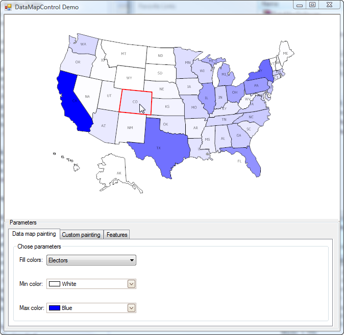
This is a "proof of concept" that the Gauges team came up with. A new developer needed to come up to speed with what the team had implemented with our new WinForms gauges product, XtraGauges, especially the vector rendering engine and he wrote a preliminary datamap control. The image shows the demo program (Windows, not WPF, remember), which is loaded with some freely available state statistics (here showing the number of electors, and the shade of blue for the state denotes the elector count in the state).

What I've also tried to capture in this static image is that the current state is highlighted with a red border as the mouse hovers over it; in this case, Colorado.

The map is a vector drawing with the GIS information stored in an XAML file. Since it's rendered as a vector image, it grows and shrinks without pixellation as the form is grown/shrunk. And yes it's very smooth at doing so.

As I said, at present this is a quick experiment to show that our XAML rendering engine is able to display other kinds of images and figures than it was first designed for. Yet I can guess that many of our customers would be interested in seeing this fleshed out into an actual product. But, instead of saying, would you like to have this product?, to which everyone would say, sure, next week would be great thanks, I'm going to couch this in a different way:

1. If it were a choice between gauges for ASP.NET and this product, which would you choose? How about between gauges for WPF and this? Gauges for Silverlight and this?

2. If this were an extra-cost product because we had to purchase/license the GIS data for other countries or for counties within a state/country, etc, would you still be interested?

3. If this were a product without data, and you had to license the actual GIS data from a third-party (maybe we only had some basic free GIS data we shipped with the product itself, like the US or Europe), would you be bothered about it?

Let me know. All feedback is welcome.

Published Jul 18 2008, 01:28 PM by Julian M Bucknall

Comments


Mohsen Benkhellat said:

As far as I am concerned, here is my take on it:

1- Gauges for ASP.NET/WF/SL would be better

2 and 3- I am rather for a solution where you have the control independent of any source and nothing of course prevents DX from selling a service that could provide data for the control as any other provider.

Thanks for making us happy over and over

Mohsen

July 18, 2008 3:53 PM
 

Doug Leadley said:

1- Would prefer the map product over guages for asp.net.

2 - I would be ok with the extra cost for the product IF it had the right data (streets, etc) and was not a monthly cost.

3 - I would prefer 2 above.  Having to buy the data serperatly would be a potential blocker.

July 18, 2008 4:06 PM
 

Keith Lawrence said:

This is very interesting...

I would vote for 3.

Let me try to explain how I can envision using something like this.  Say I wanted to show a "map" of our Company it would be an abstract map if you will.  Each "State" would represent a physical location and could be colored by some performance metric and display some number inside the block.  Then I click on a plant and it shows me a representation of the plant with each machine and the machines are colored by performance with production data inside the representation.

And as an extra added bonus it can "look" like the physical layout of the equipment.  That would be awesome.

Of course I would need a tool to help me draw and or create the maps from a bitmap or autocad etc. :)

Or am I in left field from where you going with this.

Keep up the great work.

July 18, 2008 4:07 PM
 

heather said:

From our perspective we prefer ASP.NET and then Silverlight.

Once we have mastered Silverlight and it is as stable as we need it to be - we will be going Siliverlight fullspeed ahead.

The gauges and maps are a very big plus and hopefully we will see them both soon.  Currently we use another vendor for this capability but we would like to have one component architecture is possible and quite frankly Dx is so close to being able to provide that.

Keep up the great work and let's see lots more like this.

As for extra costs, we think the extra fee for the GIS data would be worth - you might want to consider the GIS fee as a pass-thru so you stay competitive in regard to the cost of the data.

Thanks for sharing Julian - posts like this really keep us pumped.

July 18, 2008 4:12 PM
 

Evgeniy Meyke said:

I wonder how many DX clients that build GIS apps are holding their breath now...

July 18, 2008 4:15 PM
 

Evgeniy Meyke said:

DX distributing GIS data - bad idea in my opinion

DX GIS controls - worth paying (much) extra

July 18, 2008 4:26 PM
 

Danilo Mendoza_1 said:

I vote for 3 for the same reason that Keith Lawrence

July 18, 2008 4:31 PM
 

Andre Prins said:

Gauges for ASP.NET. WPF and SL first, please.

July 18, 2008 4:41 PM
 

Linton said:

1. Would prefer it before ASP.Net

2. No extra charge-only public domain GIS supplied

3. User (developer) should provide specific (non-public domain) GIS data.

July 18, 2008 6:12 PM
 

John Harrison said:

Well, I personally would prefer to see the XAML renderer for winforms promoted to an actual usable tool, because the WPF interop support is SLOW to startup (as is all WPF at the moment)

I think the maps control would be of limited use in comparison.

July 18, 2008 6:23 PM
 

Paul Fuller said:

I would prefer a mapping control over gauges.

Include some high level world / country / state boundaries.  Should be freely available.

There are many specialised map data providers out there.  So DX should enable such data to be used within the control but we licence such data separately.

If DX approached one or more of these providers you could probably get the high level stuff for free as they will want to guide users towards their paid services.

Like others have commented, what would be more useful than either would be if you release the underlying graph control.  Give me a XtraCanvas !

July 18, 2008 7:29 PM
 

Michael Reith said:

1) I would like to see the mapping control over the ASP.NET, WPF and SilverLight gauges.

2) I probably wouldn't purchase if there were a extra charge for this or if it came without any data.

3) Releasing with some rudimentary free data would cover most of my needs. If I needed something more complex being able to purchase some data and use it in the control would be great.

I keep envisioning a executive dashboard for my company and this would be a perfect fit within that idea.

Looks really great, Julian! Thanks.

July 18, 2008 8:11 PM
 

Kevin White said:

I would prefer the map control over ASP gauges, I would also say that you should offer the control and the data separately, some of us already have  data or use census data and have no need for purchased data. Of course since you guys are magicians just do it all...next week would be a good ship date.

July 18, 2008 8:21 PM
 

Geoff Davis said:

My take is:

1. ASP.NET Gauges first, Real business dashboards will then be available through the web server. I would like to see the Gauges suite complete. Love the fact that your products are mostly available in Windows and ASP.NET. Offers true flexibility. We use another 3rd party gauges (errrmmm) at the moment in ASP.NET. Maps would also be nice but I can only think of one application I would use for that right now.

2. I'm a Yorkshire man so don't like spending money. It would put me off somewhat as i'm already a Universal licensee and want it all!, all damn it! :-)

3. Don't like the idea of a middle man. If it comes down to it I would rather get GIS data directly from you guys as you will probably be more knowledgeable of what is required for the customer needs based on the solutions we are trying to architect based on your products. Include UK if it goes that way though! :-)

July 18, 2008 8:59 PM
 

Alain Bismark said:

I prefer, the "devex rendering engine of XAML" as a component, and let us to use this in any way that we decide.

I think that a real GIS component need a lot of things to be competitive, projection management (mercator, projections tranformations , functions to handle layers, functions to draw objects over the maps, etc, etc).

Finally ASP Gauges are more "useful component as devex style".

July 18, 2008 9:12 PM
 

pat roam said:

Would prefer this over the ASP gauges and since there are many sources for GIS data it not being included or available a la carte would be my preference.

July 18, 2008 9:54 PM
 

Luc DEBRUN said:

1. Definitely we would prefer Map Control over gauges for ASP. Been dreaming about this for some time.

2. DevEx just introduced a Universal subscription with a higher price. Please dont introduce yet another level.

3. Some basic maps (say 1 world map + 1 map for each continent) should be provided as part of Universal. Other maps may cost extra. I suggest that you enter into some agreement with a map supplier. They would provide you the basic maps for free for inclusion in Universal, against a lot of advertizing for those of us who  need more maps. The pitch would be that compatibility and support is assured if we buy from them (cause I dont want to send a support request to one company to be told that the problem is with the other and when checking with the other being told that's its wrong).

4. Please dont forget XAF integration.

Luc

July 19, 2008 1:26 AM
 

Rollie Claro said:

1. I Prefer Gauges over this

2. If this has price tag on it, it will be painful

3. this should be included in the universal subscription without jacking up the subscription's price

4. there should be an ASP.net equivalent of this

July 19, 2008 1:59 AM
 

Jerrie Pelser said:

1. Gauges for WPF

2 & 3. Not too worried about something like that

July 19, 2008 4:37 AM
 

Christoph Brändle said:

1. prefer Map Control

2. extra cost is ok (pls provide whole europe with all country/states)

3. licensing GIS data from 3rd party is complicated, needs documentation, confusing all, why not provide additional GIS data for extra cost? most need one country, so it dont hurt.

looks great though!

July 19, 2008 6:06 AM
 

Conrad Akunga said:

Gauges anytime. The problem with maps is that to a man all vendors seem to assume the only places that exist are America and Europe. This leaves some of us (Kenya baby!!!) in a bit of a bind.

Unless of course you can make the product truly international

July 19, 2008 7:12 AM
 

Evgeniy Meyke said:

To those interested, there is a suggestion: www.devexpress.com/.../CS48230.aspx

July 19, 2008 8:10 AM
 

Alex Danvy [DX-Squad] said:

I'm really interested in such component as I'm actually investigating in the subject.

1) In this ordrer : Maps for WinForms, Gauge for ASP.net and Gauge for WPF

2) Extra cost is not a problem if there is a real extra value

3) Rely on third party as long as DX invest in the partnership. I had some bad experience with XtraSpellChecker were OpenOffice dictionaries were not fully supported.

July 19, 2008 10:00 AM
 

Greg Shelton said:

1) ASP.NET Gauges first

I would be interested in such a control, but would be fine just a basic GIS dataset thrown in and point me in the direction of where to obtain more data, if needed.

July 19, 2008 10:21 AM
 

Holger Persch [DX-Squad] said:

1. We would prefer the Map control.

2. Basically yes, but it may depend on the maps that are coming with the product. Since each customer would like to have different maps it may be better for customers to purchase the maps separately from the Map control.

3. No.

July 19, 2008 11:17 AM
 

Mark Krasnohorsky said:

1) Map Control

2) Yes, provided the licensed data was of use.

3) No, it would still be very useful. I have clients that have their own GIS data sets so this would be fine in many cases.

July 20, 2008 6:02 AM
 

John Doe_4 said:

Anyway, please provide read/write (import/export) support in your components for most common/popular GIS-formats like ArcGIS Shapefile.

Vote for #3. We have own specific geo-data, not just countries borders and common stuff like that. We use own geo-data for rivers, polution sources near rivers, plants, some roads and GPS traffic jams data, so... as PM & developer I suppose it's better to have very flexible GIS-like engine from DX without extra cost for geo-data we don't need.

July 20, 2008 6:43 AM
 

Robert Fuchs said:

1) In this order: Maps for WinForms, Gauge (+Maps) for WPF, Gauge for ASP.net

2) Yes, of course. But would prefer 3)

3) No, not all, as long as public domain data, which is available, is shipped with the product.

And prepare interfaces to other GIS formats.

July 20, 2008 11:35 AM
 

Melvin Foo said:

can we have both together? haha. it would be good if the gauge can work together directly with the GIS where by the GIS will reflect the color from the gauge's threshold which define by the user.

July 20, 2008 9:43 PM
 

Antonio Terron said:

1. Would prefer it before ASP.Net

2. There is public domain GIS data

3. User (developer) should provide specific (non-public domain) GIS data.

July 21, 2008 3:15 AM
 

VCL Win32 User said:

Please consider "DevEx XAML rendering engine" for VCL (Win32).

July 21, 2008 3:35 AM
 

John Botibol said:

1. Maps, maps, maps. (Then Silverlight maps!)

2. May be seperate product but include in DX Universal with PD data. Ensure compatibility with PD and commercial data.

3. Happy to licence data where neccessary but basic PD data very adequate for masic management reporting and analysis. An extra tab on XAF Analysis module? Wow!

Thanks for sharing Julian.

July 21, 2008 4:25 AM
 

Reader Man said:

1. in this order: gauges for WPF, The rendering engine.

2. make it compatible with the GIS and leave it for the client to buy what he wants.

3. Yes it will stay benificial.

July 21, 2008 5:05 AM
 

Linton said:

I'd like to add my support to all the posters saying Universal should include everything DevEx has developed or will develop in the future. Unless, of course, DevEx can provide some undisputed proof for parallel universe(s) theory in which some objects exist in one universe and not the other :-)

July 21, 2008 11:05 AM
 

David Dillon said:

since I have a client who wants gauges for their website yesterday, ASP.net 1st is my self-serving vote.  Looking forward to the rest in short order, though.

July 21, 2008 2:58 PM
 

Garth Henderson said:

1) Gauges for Silverlight but GIS to follow.

2) & 3)  I would like to have the GIS functionality included in the Universal Subscription with options for GIS connectors and an open API to build connectors.  I'm OK in paying for the GIS connectors and services that I need.  I would encourage 3rd party connectors from our gobal community.

I'd also like to have this functionality expanded to support drill down connectifity XAF Views from images and vector diagrams.  It seems like the underlying technologies would be related.  This concept also applies to the creation of graphical navigation dashboards for XAF.

See:

www.devexpress.com/.../Q103807.aspx

July 21, 2008 3:34 PM
 

Julian M Bucknall said:

All : Just a quick note to say many thanks for your feedback and suggestions. It's given the gauges team (for it was they who produced this demo) a lot to think about. And... please keep the feedback coming!

Cheers, Julian

July 21, 2008 4:56 PM
 

Masa Ito said:

1. Much prefer winforms maps first

2. Happy with the public domain GIS data

3. I can provide my own GIS data, or get it myself.

July 21, 2008 5:05 PM
 

Steve Sharkey said:

Clearly different DevX users have different priorities but for me...

1. Maps first - I've been using other software to do this up until now - it is always nice to have all the right tools in the same toolbox. It is also nice to get something so I can start learning the new component earlier rather than later. If I was going to add guages to my web forms app then I could at least start testing out my ideas on the winforms stuff. Then I'd go for guages ASP as for WPF & Silverlight (I may get around to that in 2009 sometime...).

2. If it was extra cost because of the data then leave the data out and let existing providers of such data provide. As others have said you can get some freely available sources which could be shipped with the product. I have to agree with someone elses comments regarding the spell checker - I have had hassle getting a suitable dictionary and have abandoned it's inclusion in my applications (for now) due to more pressing things. So there is merit in linking with an existing provider of data and get them to do the formatting work with their data and using them as the "recommended provider" but please don't make such a tie in mandatory (this kind of facility will get used for more that the obvious geographical maps).

3. Yes this is the ideal model IMHO.

July 22, 2008 3:16 AM
 

Andrey Makhorin said:

Adding GIS abiblity in our solution is very important for me and my customers. Thanks to DevX - great work!

1) Maps first.

2) some public GIS data without extra cost prefer

2) any specific GIS infomation I can get by myself

July 22, 2008 3:30 AM
 

Paul A. CHEVALIER said:

This seems to be a very interesting feature for us.

1. I would like to have the map control before ASP or WPF.

2. I don't need public GIS data at all and would probably be reluctant to pay.

3. We have GIS data and it would be important for us to make our own customized maps.

July 22, 2008 3:57 AM
 

ALEXANDROS VOUSVOUNIS said:

1. We would like to have the map control before ASP or WPF

2. We are not interested for GIS Data

July 22, 2008 8:39 AM
 

Antonio Caregnato said:

1. Map is very important function before gauges in ASP or WPF

2. I prefer to pay and have the correct maps from Devexpress, so that they have been tested and are correctly working, instead of trying to make some external library to work... I had experience for examples with the dictionaries of spell checker, it was not straight to find the right ones, and also that one were not so good... Better you give ALSO your full solution without stress for developer. I appreciate eXpressApp, and with the same RAD logic, I prefer the complete maps solution.

3. Best solution for me is that you sell product with free GIS for starting point, for customers who have low budget. And more than this, that you sell the "professional DevExpress maps" as a separate product for customers who prefer to get the full optional solution.

After this, in my opinion, I don't care if DX Universal Subscription will be more expensive (I married DX for every software I develop), the important that everything is tested yet and ready to work as RAD logic suggests.

July 24, 2008 6:05 AM

Leave a Comment

(required)  
(optional)
(required)  
Verification code: Required
   
Add
Copyright © 1998-2008 Developer Express Inc.
ALL RIGHTS RESERVED