Blogs

Thinking Out Loud

WPF Silverlight Map Control (an early preview)


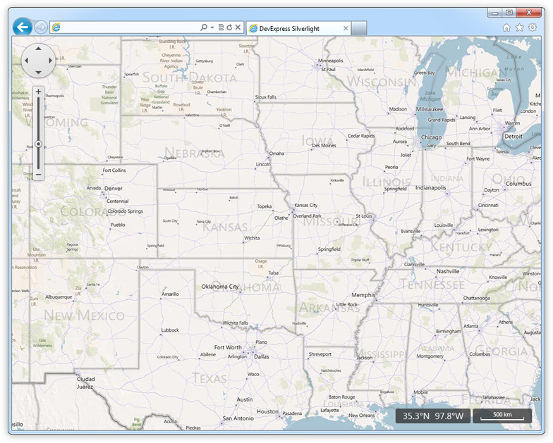
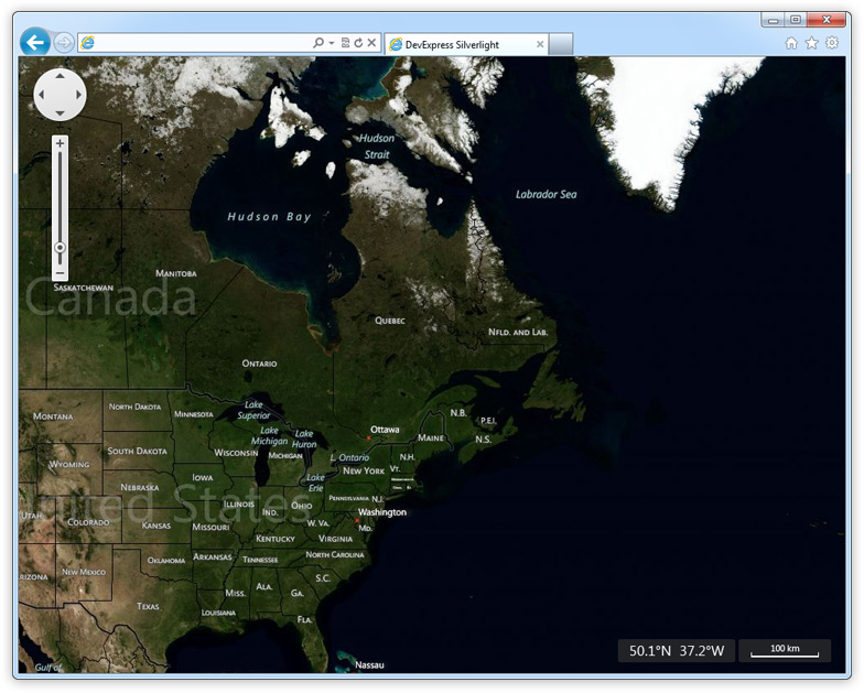
As part of our BUILD Conference related announcements, I wanted to share an early preview of the DXMapControl for the WPF and Silverlght Platforms.

The following are planned features for our WPF and Silverlight Map Controls:

Online Data Providers - Bing Maps and Open Street Maps.
Multiple Layers - This feature allows you to add Image Tile layers and Vector layers to a given map.
Vector Elements - such as MapCustomElement, MapLine, MapPolyline, MapPolygon, MapEllipse, MapRectangle to draw figures on a map.
Shapefile Support

Here are a couple of images demonstrating the control - we have a ways to go with this product, so feel free to provide your feedback and comments...

WPF and Silverlight Map Control

WPF and Silverlight Map Control 

Published Sep 15 2011, 12:35 AM by Ray Navasarkian (DevExpress)
Technorati tags: WPF, xaml, map, Build Conference, Silverlight
Bookmark and Share

Comments


Daniel Rieck IMC said:

Is the WPF version hosting a WebBrowser control?

That's what we do when we need to show a map in our appications, but has the side effect that the map doesn't show up when we render the window to an image to make a screenshot.

Also, if you need a beta tester for the WPF version, let me know :)

September 15, 2011 3:31 AM
 

Michael Proctor [DX-Squad] said:

Umm... you missed WinForms support didn't see the word XtraMapControl anywhere ;)

We utilise Mapping in our Business software to allow customers to schedule jobs being spatially aware of distances between jobs and obtaining driving routes/distances.

It is also used in a call centre scenario where staff can check where a town is quickly and identify the closest dealer to redirect the caller to.

Mapping is a great addition, however WinForm support for mapping is very poor and we are relying on a public open source solution which has some questions over it's use of copyright data.

Don't suppose DX could research the ability to host this control within a WinForms app? From the patchy bits I have read it does appear possible to host WPF controls within WinForms. However I must admit I haven't looked into it thoroughly.

Look forward to seeing more and as always great work guys.

September 15, 2011 3:33 AM
 

Ray Navasarkian (DevExpress) said:

Daniel - if you own DXperience Universal or Enterprise you'll have access automatically. If you dont and once we announce, simply contact our support team and let them know you are ready to test. :-)

To your question - no it's not. You'll be able to use RenderTargetBitmap for your screenshot.

September 15, 2011 3:51 AM
 

Ray Navasarkian (DevExpress) said:

Michael - hopefully we'll see you in Vegas at our DX-Squad Summit...we appreciate everything you do for our user community. Much like other WPF controls, our Map control can be hosted in a WinForms application using standard WPF hosting techniques.

But...we tend to agree with you, we need to have a WinForms and ASP.NET versions and we will certainly be working on those in due time.

September 15, 2011 3:55 AM
 

FreSoft said:

I waiting for this a very long long time. Is nice if you create too a ASP.net Version

September 15, 2011 4:42 AM
 

Michael Friis said:

Openlayers already provide an excellent webbased mapcontrol with lots of possibilities.

If you wrapped this in a ASP.NET or MVC control you could deliver a very powerfull tool. OpenLayers is very JavaScript intensive but could become more .Net developer friendly if done like your Grid or similiar web controls.

Pitneybowses have done something a bit similiar with Stratus (in the link above) but is more of a packagedeal than a developer tool.

September 15, 2011 5:02 AM
 

Mark Bissett 2 said:

+1 for a WinForms version.

September 15, 2011 7:22 AM
 

Mateus Lopess said:

Google Maps ?

September 15, 2011 12:32 PM
 

Michael Proctor [DX-Squad] said:

@Mateus Lopess

I too would love Google Maps as their coverage here in Australia is brilliant, whereas Bing Maps are behind in details. However the way Google operate the only way to interact with their mapping is via their Javascript library, any other decoding of their API's is against their license agreement. GreatMaps (a codeplex project) recently went through this process as they had cleverly worked out the api and rewrote it in WinForms .NET to build the correct URL's to build a map. Unfortunately it is against their licensing and was forced to be removed. MapSuite does allow for Google Imagery but it is a "hack", they grab a bunch of Google Static Maps and stitch them together to build a map meaning Google copyright logos all over the place.

I am hoping at some point Bing Maps will improve it's satellite coverage to other places outside the US (better Satellite coverage) and improve its road data.

September 15, 2011 5:42 PM
 

Robert Fuchs said:

@Michael

I agree, Bing and Open Street are crap compared to Google.

Their satellite resolution is close to unusable here in Austria - and I guess everywhere outside of the US.

September 15, 2011 6:25 PM
 

Robert Fuchs said:

+1 for Winforms

September 15, 2011 6:26 PM
 

Robert Fuchs said:

@Michael

re. GreatMaps: the code for Google is still there ;-)

September 15, 2011 6:27 PM
 

Norbert Kustra said:

+1 for WinForms version

September 16, 2011 2:19 AM
 

Michael Proctor [DX-Squad] said:

@Robert.... Shhh.... "i dont use that control due to licensing concerns".....

September 16, 2011 6:11 AM
 

Sascha said:

I would suggest enabling touch on this control. Maps on touch systems are almost always a question of customers when it comes to develop touch based systems for exhibitions or corporate info systems.

September 16, 2011 10:21 AM
 

Robert Fuchs said:

> @Robert.... Shhh.... "i dont use that control due to licensing concerns".....

@Michael

I want to publically declare that I don't use this control either ;)

September 16, 2011 5:24 PM
 

Egmont Goedeke said:

Other useful features would be:

Allowing Vector Elements (e.g. polygons etc.) to be loaded from a SQL Server database (using the Geospatial datatypes) in addition to shape files.

Ensuring that the map control can work in "offline mode" (i.e. that it does not always have to be contected to the internet to work)

September 18, 2011 6:32 AM
 

Holger Persch [DX-Squad] said:

@Ray: The only thing that springs to my mind that may be missing is something like  binding support to a collection of map elements e.g. MapLine or MapPolyline. That will allow to load routes from a data source and draw them easily.

September 19, 2011 2:28 PM
 

Alex K (DevExpress) said:

@Sacha: We have plans to support touch screens in our Map control. Please look for our blog posts...

@Holger: We have implemented binding to a collection of map elements in our internal builds.

@Egmont: Thank you for your feedback - we will consider adding these features in the future!

September 20, 2011 12:03 PM
More from DevExpress
Live Chat
Have a pre-sales question?
Need assistance with your evaluation?
We are here to help.
Chat is one of the many ways you can contact members of the DevExpress Team. We are available Monday-Friday between 8:30am and 5:00pm Pacific Time.
If you need additional product information, require pre-sales assistance, or want help with your order, write to us at info@devexpress.com or call us at
+1 (818) 844-3383.